Projects and Portfolio
This is a listing of some of our highlighted project activity. It includes collaborative efforts between CDRP staff and students as well as ongoing applied efforts with outside agencies. It is not all inclusive, and may not include unpublished work or smaller projects.
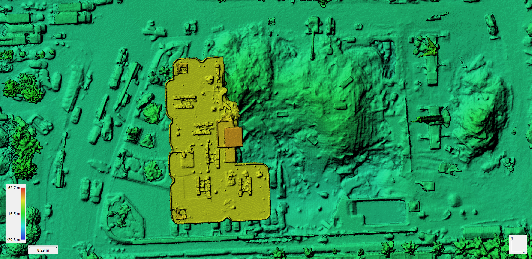
National Science Foundation RAPID: Data Collection for Robot-Oriented Disaster Site Modeling at Champlain Towers South Collapse
NSF 2140573 was awarded to CDRP in August of 2021 in collaboration with Texas A&M University and Carnegie Mellon University. The grant will support the creation of models and datasets from data captured at the Champlain Tower collapse in Surfside, Florida.
CDRP was part of the initial response to the Champlain Tower collapse, and spent 25 days on site working as part of Florida’s Urban Search and Rescue (US&R) efforts. Center personnel partnered with Miami-Dade Fire Rescue, the Miami-Dade Police Department, the City of Miami Fire Department, the Federal Emergency Management Agency (FEMA), the State Emergency Response Team (SERT), and the National Institute of Standards and Technology (NIST) to build multiple two-dimensional maps and three-dimensional models. These products were created using small unmanned aircraft systems (sUAS), or ‘drones’, which took hundreds of still photos of the collapse site every few hours. The workflow pioneered by CDRP and FEMA on this event created rapid, accurate, and actionable imagery that was utilized on the collapse pile to locate and tag key evidence and other material during search and recovery operations.
Disaster Imaging Project
The Disaster Imaging Project is an internal project designed to demonstrate the value of public-private partnerships in gathering near real-time imagery after disasters. During the response and recovery phases after a disaster, decision makers suffer from a lack of quality, timely information about conditions in the impact area. Details such as the extent of physical damage, the status of infrastructure, and passable routes into and out of the area are consistently scarce. As technology improves and the cost of remote sensing declines, local and state emergency managers are turning to manned aircraft, satellites, and small unmanned aircraft to provide immediate imagery of the effected areas. At the same time, private sector entities including insurance companies and utility providers have similar data needs and are collecting similar images. CDRP is partnering with private sector entities to safely collect, process, and deliver post-disaster imagery to support local and state disaster management efforts. This project serves as a proof of concept that collaborative teams conducting post-disaster remote sensing data can fulfill the needs of public and private users in a safe and efficient manner.
Nimble Networks Communications Workshops
Nimble Networks consisted of multiple workshops conducted throughout Florida, both in-person and virtually, in the 2019 calendar year. Each of the seven Regional Domestic Security Task Force (RDSTF) areas hosted workshops allowing counties and municipalities to gain understanding of their communications needs and how the National Public Safety Broadband (NPSB) network, also known as FirstNet, can improve communications. Emergencies, disasters, large gatherings, and other events can stress existing communication tools and NPSB can prioritize the communications of first responders. This work was completed in conjunction with Florida Department of Management Services (DMS) and private cellular network providers.
I3 Exercise
The “Interdependent Infrastructure Incident” (I3) exercise will feature a tabletop (discussion-based) exercise within the framework of a simulated disaster scenario. Experts in emergency management, transportation, communication, power utilities, water utilities and government from the Florida peninsula are encouraged to participate. Participants will be asked to share the information and criteria used to make decisions related to infrastructure restoration and prioritization. In addition to engaging individual experts, roundtable discussions will allow participants to interact with their colleagues from other agencies and disciplines. The I3 project was funded through an NSF grant awarded to Florida Atlantic University, Georgia State University and Lehigh University. CDRP was engaged for assistance with this project based on its long standing reputation for excellence in exercise development and their expertise in HSEEP compliant design. The I3 exercise is organized by the PRAISys Team and will utilize CDRP's Tabletop Exercise System Technology (TEST) software.
National Science Foundation RAPID: Hurricane Irma UAS Dataset
NSF 1762139 was awarded to CDRP in September of 2017 in collaboration with Dr. Robin Murphy at Texas A&M University. The grant will allow the datasets of UAS imagery and data taken in Harvey and Irma to be cleaned, processed, analyzed and published for public use. CDRP and HRAIL data are available at: hrail.crasar.org and cdrp.crasar.org.
Governor's Hurricane Confernce Social Media Exercise
CDRP has developed and run a social media based exercise at the Governor's Hurricane Conference each year since 2013. This exercise is designed to introduce emergency managers attending the conference to the capabilities of social media before and during a disaster. These exercises used fun and engaging activities to encourage conference attendees to participate during the week and provided valuable lessons and outcomes.
Florida SERT Air Operations Branch
CDRP is a rostered parter in the State of Florida's Air Operations Branch (AOB). CDRP personnel staff two positions in the AOB - Air Mission Coordinator and UAS Coordiantor. In these roles, our staff help coordinate manned and unmanned avaition resources and missions throughout the state during a disaster.
Disaster Incident Research Team (DIRT)
This ongoing program provides a framework and policy for conducting a variety of applied research activities in the field. DIRT research may include data gathering in disasters for academic research projects as well as applied work in the areas of unmanned systems, urban search and rescue, and business recovery.
Florida Virtual Business Emergency Operations Center
Disaster Contractors Network

FSU Disaster Intelligence (FSU.DISINT)
CDRP/EMHS operates a Disaster Intelligence team (DISINT), formerly called a Virtual Operations Support Team, that supports the State of Florida's State Emergency Response Team (SERT) and other partners during activations for disasters and critical incidents. DISINT provides information support and situational awareness by utilizing student volunteers to mine social media during incidents. This information helps our partners understand what is happening with the public and improves decision making. DISINT is a unique opportunity open to interested students from EMHS and other disciplines. More information is available at http://fsuvost.org.
Disaster Management Training Development - Rosseau, Dominica
CDRP faculty members worked closely with the Florida Association of Volunteers Active in the Caribbean and Americas (FAVACA) to conduct training sessions with local emergency managers on the island of Dominica. Trainings were designed specifically for Community Emergency Response Team (CERT) leaders with sustainability in mind so that these leaders could then train future CERT members.
Governor's Executive Tabletop Exercise - Cyber Sunset 2011
Disaster Housing Resources
Applied Emergency Management Studio - Tierra Amarilla, Atacama Desert, Chile
Faculty, staff, and four students from CDRP partnered with Candelaria Mining Company in Tierra Amarilla, Chile and the University of Chile in Santiago. Over the course of 5 days, students led trainings in disaster preparedness and, in particular, training community members on a communication plan designed specifically for the Tierra Amarilla community. Students designed the plan themselves and ultimately found their project to be a great success with project partners and participants. Community members stated that they felt better equipped to communicate with friends and family regarding the dangerous hazards and effects of natural disasters.
CDRP became initially involved in this project in the aftermath of an extreme flooding event in the Atacama Desert in March 2015. Although it is the driest place on earth, severe rains caused uncharacteristic conditions in the region, leading to the flooding of several populated areas. Tierra Amarilla, a town of about 11,000 residents, was impacted by this disaster, and many survivors lost loved ones, their homes, and possessions. In a disaster of this magnitude, it is often difficult to communicate with those affected. FSU EMHS faculty and staff advised students on the development of the communication plan for Tierra Amarilla, bearing in mind the physical and technological constraints of communication in the region.
Applied Emergency Management Studio - San Mateo, Ambergris Caye, Belize
The Disaster Incident Research Team (DIRT), consisting of faculty, staff, and six student researchers, conducted field research in San Mateo, gathering information on demographics and resources within the community. The team partnered with the Belize Red Cross, whose members provided vital insight and knowledge about San Mateo and the greater island community.
The project was divided into two parts:
- Teams of CDRP staff and student researchers surveyed San Mateo community members to gather data on the community’s vulnerabilities to disaster. Community members were asked primarily about infrastructure, utilities, and bills and taxes paid to the local government.
- Members of the CDRP team flew several UAS missions throughout San Mateo. Employing the use of small Unmanned Aerial Systems (sUAS), the team took photos and recorded video of the community so as to construct orthographic photos and gain a better understanding of the physical aspects of San Mateo.